Angaben zur Landkarte im Überblick:
Verleger / Kupferstecher: A.D.Bache, Superintendent of the Survey of the Coast of the United States
R.D.Cutts, Assistant
A.M.Harrison, Sub-Ass.Lieut. James Alden, U.S.N. Asst.
Maßstab : [Ca. 1:40.000]
Erschienen: Published in [1852]
Anmerkungen : Original Stahlstich
Größe der Abbildung : 29,5 x 33 cm
Größe des Blattes: 33, 5 x 38 cm
Zustand : sehr gut
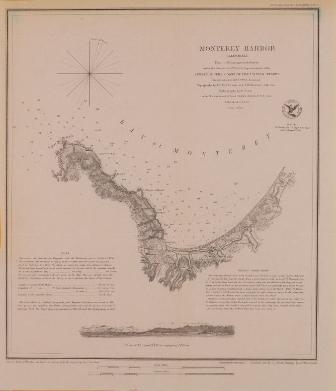
Original Stahlstich der Vermessung der Küste Kaliforniens aus dem Jahre 1852.
Der Stich zeigt die noch weitgehend unbesiedelte Bucht von Monterey zwischen dem heutigen Pacific Grove und Sand City. Straßen und Gebäude im Zentrum der Stadt sind gut zu erkennen: church, custom house, ruins of a fortified Mexican battery and the cemetery. Markante Küstenpunkte sind: Point Pinos, Pt. Aulon, Rocky Pt., Pt. Almeja or Mussell und the Lagoon.
Unter der Karte eine Ansicht vom Meer in Richtung Point Pinos; dahinter die Bucht von Monterey und die Berge von Salinas.
Der Kartentitel oben rechts „Monterey Harbor California – From a Trigonometrical Survey under the direction of A.D.Bache, Superintendent of the Survey of the Coast of the United States. Triangulation by R.D.Cutts, Assistant and A.M.Harrison, Sub-Ass.. Hydrography by the Party under the command of Lieut. James Alden, U.S.N. Asst.“. Darunter das Siegel des Coast Survey Office.
Die Vermessung fand unter Leitung von A.D.Bache, Superintendent of the Survey of the Coast of the United States, statt. Er wurde unterstützt durch R.D.Cutts, Assistant, A.M.Harrison, Sub-Ass. und Lieut. James Alden, U.S.N. Asst.
Oben links eine Windrose.
Unten rechts umfangreiche Hinweise zum Segeln in der Bucht.
Meilenanzeiger unter der Abbildung (Statute Miles, Nautical Miles).
Vgl.
Slotten, Hugh Richard, The Dilemmas of Science in the United States : Alexander Dallas Bache and the U.S. Coast Survey. In: Isis , Vol. 84, No. 1. (Mar., 1993), pp. 26-49.
Schreibe einen Kommentar